 |
| Erupting Hawaiian Volcano |
Anytime we've traveled to a new place, one of the fascinations is not only the new trees and flowers, but also the geography and sometimes even the geology. An uber example is Hawaii. With every successive wave of immigration, the types of flowers and trees increased as the new immigrants brought seeds of their favorite plants from the 'old country' whether it was Portugal, China, Japan, New England, or the Philippines. With the temperate Hawaiian climate, very few failed to flourish. These new plants crowded out the native vegetation, so today more than 95% of what we consider Hawaiian plants are actually intruders. The Hawaiian geology - all new real estate created by volcanoes - stole the show even over the vegetation.
 |
| Ancient Ocean (black w/trees) and Mantle (mesa) |
As we've crossed Canada, we've come to appreciate not only the changing flora, but also the interesting geography, and the geology. Newfoundland is a land with one of a kind geology: The Earth's mantle sits next to an ancient ocean bed. Our hike of the tableland area whetted our appetite for the geology of Canada. As the Ranger told us, the tableland was heaved up from the interior of the earth together with heavy metals which make it pretty much toxic to plants and even to animals that eat the few they find. This geologic phenomenon has actually helped prove the tectonic theory of the continents movements.
Another geologic wonder of Newfoundland was the Western Brook Pond. It's an enclosed fjord. Retreating glaciers gouge huge holes in the land which fill with water which drains into the sea, and voila, a fjord.
 |
| Western Brook Pond |
In Newfoundland, the glacier obligingly gouged the hole, but the spongy marsh at the end of the hole filled up with water and cut the fjord off from the sea. Thus, a landlocked fjord fed completely by snow melt. (Oh, FYI, any body of water created by a glacier is called a 'pond' in Newfoundland.) The Western Brook Pond is 220 meters deep (in the middle), and the water is so pure, it doesn't even have electrolytes in it.
We've become fascinated with Pangea. That's when all the land on earth was smooshed together as one large continent. The land slowly broke apart and drifted around to form the earth we have today. Newfoundland actually belongs to a different part of Pangea than the rest of North America, so they have different rocks there.
 |
| Drake, being perspective for the sea pillars |
The mountains of Eastern Canada are worn down just like the Appalachians. These are ancient mountains which at one point were bigger and higher than the Rockies, but time has eroded them. The highest peak we've seen is under 3000 feet by a goodly amount. Sometimes erosion of wind and water creates some great scenery. Here's an example of 'sea pillars' which we saw in Arches Provincial Park in Newfoundland. These pillars are surrounded by cobbles, big and small - rocks tumbled and tumbled by the ocean, so they are perfectly smooth and rounded. When the sea is 'up', you can actually hear the cobbles clicking together like castanets as the waves roll in and out.
There are quite a few new to me wild flowers. When lupine season rolled around, they made me homesick for Texas bluebonnets. Here's a side by side comparison. I can see the similarities, but I never, ever saw a blue lupine with red dots.
 |
| Texas Bluebonnet |
 |
| Purple Lupine |
You can find lupines in white, pink, purple and coral, and they are bigger than bluebonnets. Definitely 'kissin' cousins', don't you think?
I've enjoyed taking pictures of the 'formal' flowers, like the peonies which people grow in their yards in the Atlantic Maritimes, and the informal flowers on the side of the road. It's also interesting to realize that some wildflowers, like lupines, can be cultivated (Susi and Marilyn S, you are going to have your chance!) while others wither and die when gardeners attempt to 'grow' them. I'm convinced originally, there was one color of lupine, but cultivation and hybridization created the rainbow of colors. Oh, and the flowers have changed beside the road as we've eaten up the miles. Now, in Saskatchewan, we are at the peak of the summer, actually probably just over the peak, and the roadside flowers are almost non-existent. I actually miss them.
 |
| Spring green trees |
We experienced (by my count) four spring times this year. One of the best things about spring is the ethereal shade of green when the leaves first come out on the trees. In a normal one spring year that color only lasts for a few weeks. Spring green surrounded us for more than a month. It was so very lovely.
 |
| Rhododendrons in Nova Scotia |
Two types of flowers surprised me. I never expected azaleas or rhododendrons in such cold climates. The rhodies were in such a profusion of colors from peppermint pink to the shades of the sunset. Super spring time will remain one of my favorite memories of Canada.
 |
| Melted Rock in Sudbury |
We accidentally stumbled onto another geologic phenomenon because of a broken clothes dryer. We had this hideous house in Toronto. SUPPOSEDLY, you had to 'slam' the dryer door to get it to start. I mean, really! Fortunately, we drenched a rug using the weirdo shower, and like good people, we washed it and tried to dry it... Do I actually have to say the slam the dryer door system didn't work? We were just lucky we didn't have a washer full of wet clothes. So, we changed our itinerary in order to do laundry and landed in the nickel mining capital of the Canada, Sudbury. And the reason it's the nickel capital is it is the site of the second largest meteor collision with the earth - well, the second largest science has found. Who knows what lurks beneath the mostly undiscovered ocean bottom? Lots of minerals came to rest in and around Sudbury including a whole bunch of nickel as a result of that collision. The area is called the 'Sudbury Basin' which is the hole caused by the collision. In addition to the concave bowl, which is obvious, there's all this melted black rock covering everything.
The elephant in the room in Eastern Canadian geography is the St. Lawrence River.
 |
| St. Lawrence River from observation tower |
It has influenced the history and economics of the entire region from prehistoric times. We drove the entire length of the river from the Atlantic Ocean to Lake Ontario. It was as if we had driven the Mississippi River from Minnesota to New Orleans. Here's the St. Lawrence as it empties into the Atlantic Ocean at the Gaspesie Peninsula.
Now I know why about 20 people a year manage to commit suicide at Niagara Falls each year. (Why anyone would choose that spot?) Drake was
 |
| Canadian Falls - called 'Horseshoe' |
gobsmacked to discover we could stand practically on top of the actual falls. He brought his binoculars thinking the experience would be like seeing Mount Rushmore - all at a distance. To fling yourself into the falls, all you have to do is climb on top of a five foot wall and step off. We decided that would be too dramatic, so we just took pictures. Personally, I would have liked to have been the Frenchman who followed the 'sound' in about 1680. Think about what his face must have looked like when he found them. The falls, which had not been harnessed with dams at that point, were three times larger! I can not even imagine what they would have looked like. When Drake told me, "they turn the falls off at night", I was outraged he would think I would fall for that. Actually, it turns out to be true because the falls are so dam controlled. They are actually repressed. We're thinking psychiatric help, but the public would be so shocked.
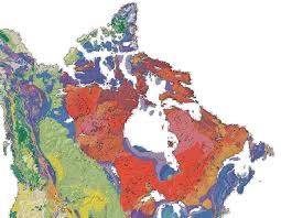
My final observation is about the Canadian Shield. This is big slab of rock laid down between 200 and 500 million years ago and which covers about one-half of Canada. It's shown in red in the picture. This geologic feature has influenced the settlement of Canada. The soil gets thinner and thinner on the Shield as you go North. Coupled with the shortened growing season, agriculture was a non-starter. Settlement of the land on the Shield was almost non-existent. The area around Lake Ontario is one of the few places where an ancient large ocean laid down enough sediment to become rich soil. And, lo and behold, that's where people settled. It's no surprise that 20% of the Canadian population (of only 35 million) live in the rich soil crescent around Lake Ontario. I finally understood the impact of the Canadian Shield when we rolled off of it - suddenly, and I mean suddenly, the prairies stretched out before us. No more rocks, just rich black soil covered with grain. I felt transported as if somehow, I was back in West Texas. We could see Winnipeg, Manitoba, from 60 miles, excuse me, 100 kilometers away. As of today, we've driven almost two complete days on this marvelous prairie. I didn't even realize I was homesick.


